NOTE: HIGH CONFIDENCE ON THIS FORECAST TRACK FOR THE NEXT 48 HOURS AND MEDIUM CONFIDENCE THEREAFTER!!
UPDATE 2/ WELL MARKED LPA (95B) | DATE: 01 DECEMBER 2023 | DAY: FRIDAY | TIME: 3:00AM BST (+6 GMT)
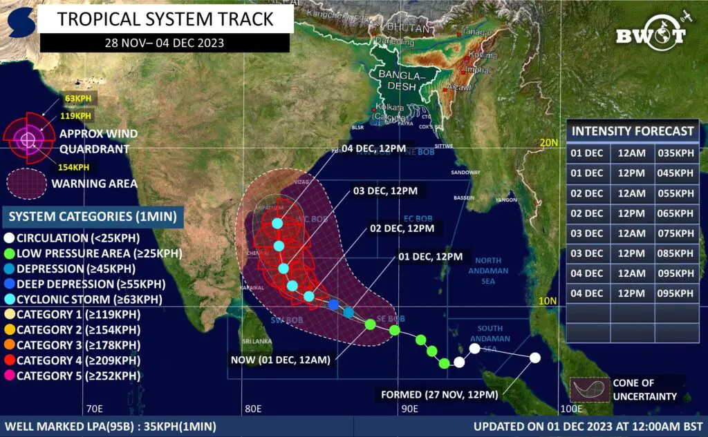
The Low Pressure Area (“Invest 95B”) over the south east Bay of Bengal has moved west north-westwards and intensified into a Well Marked LPA over the same region. It is currently located about 1530km South South-West of Cox’s Bazaar, Bangladesh.
Multi-spectral satellite animation is showing improved rotations with formative deep convection increasing across the consolidating Low Level Circulation Center.
★WINDS(1MIN AVG):-
Average Maximum Wind speed in radius of 50km from the low level center at 12am Today is 35km/h. Gusting up to 45km/h.
★Dynamic Analysis:-
Environmental analysis indicates that the system is currently in a favorable environment, with favorable sea surface temperatures (28-29°C), good moisture supply, low Vertical Windshear, moderate outflow and sufficient relevant atmospheric parameters.
• Due to the above mentioned conditions, it may gradually intensify into a Tropical Depression within next 12hours, Deep Depression by 24hrs and into a cyclonic storm by 2nd Dec.
• There is still uncertainty in the maximum intensity forecast. According to the above-mentioned atmospheric conditions, the maximum intensity of the system may be between 85-105kph(~1min) with gusting between 105-125kph.
★TRACK:-
It has moved west north-westward at an average speed of 16 km/hr during last 6 hours.
*From present location, it may move West North-westward initially and then turn North Northwestward by 3rd Dec.
★LANDFALL:-
There is still uncertainty in respect of the landfall area and intensity. But overall steering pattern supports a North Andhra Pradesh landfall or touch down between 4-5th Dec as a significant Tropical Cyclone (85kph+).
It is still possible that it may recurve northeastward just before landfall and exclude severe impact to the Indian coast by drifting towards Bangladesh.
★WARNING: –
★RAINFALL: –
Eastern India, starting from North Andhra Pradesh to Bangladesh may have Periodic rainfall between 4-8th December 2023. While rainfall may reach Bangladesh by 5/6th Dec.
SOURCES/RESOURCES USED IN THIS ANALYSIS: Global Models, Himawari 9 Satellite, CCKW, ER, 200hPa VP, 850hpa Vorticity, 500hPa Vorticity, 200hpa Winds, 200hpa Divergence, Sea Surface Temperature, OLR, WWB, EWB, Synoptic Chart, Wind Shear, Subtropical Ridge, IMD forecast, BMD forecast, JTWC Forecast.
Confidence Category:
High: Trajectory change may be limited to within 100 km.
Moderate/Medium: Trajectory change may be limited to within 200 km.
Low: Trajectory change may exceed 200 km.
Note: This information may vary along with the change of the environment. So, check new updates for more better information! Make sure to follow official information in case of making any decision.
Share as much as possible to inform everyone. Stay connected for next update!
Thanks, © Bangladesh Weather Observation Team (BWOT).

Advertisements


