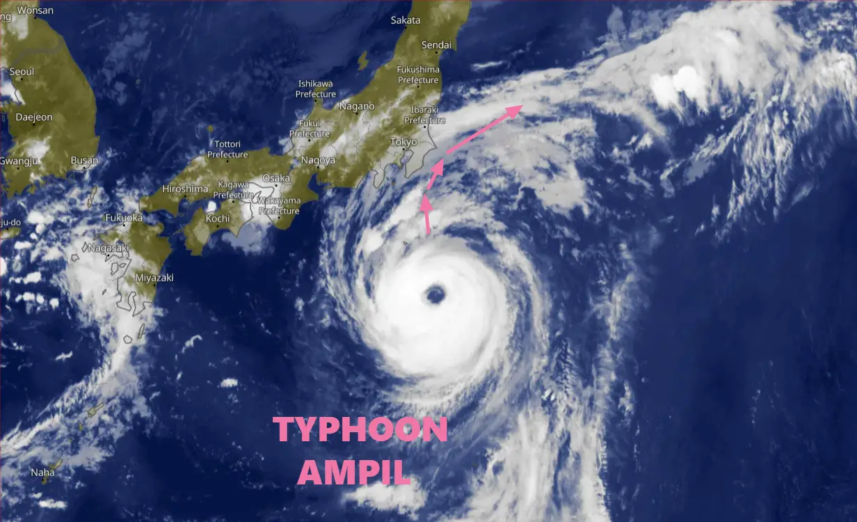
Typhoon Ampil Approaches Japan with Maximum Sustained Winds of 90 Knots (167 km/h). More Intensification in the Typhoon Ampil Forecast.
Typhoon Ampil Update Time: 151300Z (13:00 UTC on August 15, 2024) | 22:00 JST on August 15, 2024
Typhoon Ampil, currently positioned near 31.1N 141.0E, is steadily moving northward at a speed of 11 knots (20 km/h).
As of August 15, 2024, the storm is approximately 289 nautical miles (535 km) south-southeast of Yokosuka, Japan, and is expected to intensify further. The typhoon has maximum sustained winds of 90 knots (167 km/h) and gusts reaching up to 110 knots (204 km/h), with a minimum central pressure of 955 millibars.
Significant wave heights in the storm’s vicinity are recorded at 30 feet (9 meters). Forecasts indicate the storm will continue on its current trajectory, potentially impacting Japan’s eastern coast. Updates are being issued regularly as the situation evolves.
Typhoon Ampil Forecast analysis and description
Typhoon Ampil is currently making its way towards Japan, posing a significant threat with its powerful winds and potential for rapid intensification. As of the latest update from JTWC, the storm is located at 30.6N 141.0E, approximately 289 nautical miles (535 km) south-southeast of Yokosuka, Japan.
With maximum sustained winds of 90 knots (167 km/h) and gusts reaching 110 knots (204 km/h), Typhoon Ampil is a formidable force in the northwest Pacific.
Current Situation and Forecast of Typhoon Ampil
Initial Analysis and Position
-
Location: 30.6N 141.0E
-
Intensity: 90 knots (167 km/h)
-
Movement: Northward at 11 knots (20 km/h)
-
Wave Height: Significant wave heights of up to 30 feet (9 meters)
Typhoon Ampil is currently in a highly favorable environment for further intensification, characterized by strong radial outflow aloft, very low vertical wind shear, and warm sea surface temperatures ranging between 30-31°C. These conditions are expected to drive the storm’s intensification over the next 24 hours.
Satellite and Environmental Analysis of Typhoon Ampil
Satellite imagery reveals a well-defined eye and a symmetric central dense overcast (CDO) surrounding the storm’s core. The eye has become increasingly more defined over the past 6 hours, indicating strengthening as Ampil tracks northward. The storm’s current intensity is assessed with medium confidence, based on various agency Dvorak estimates.
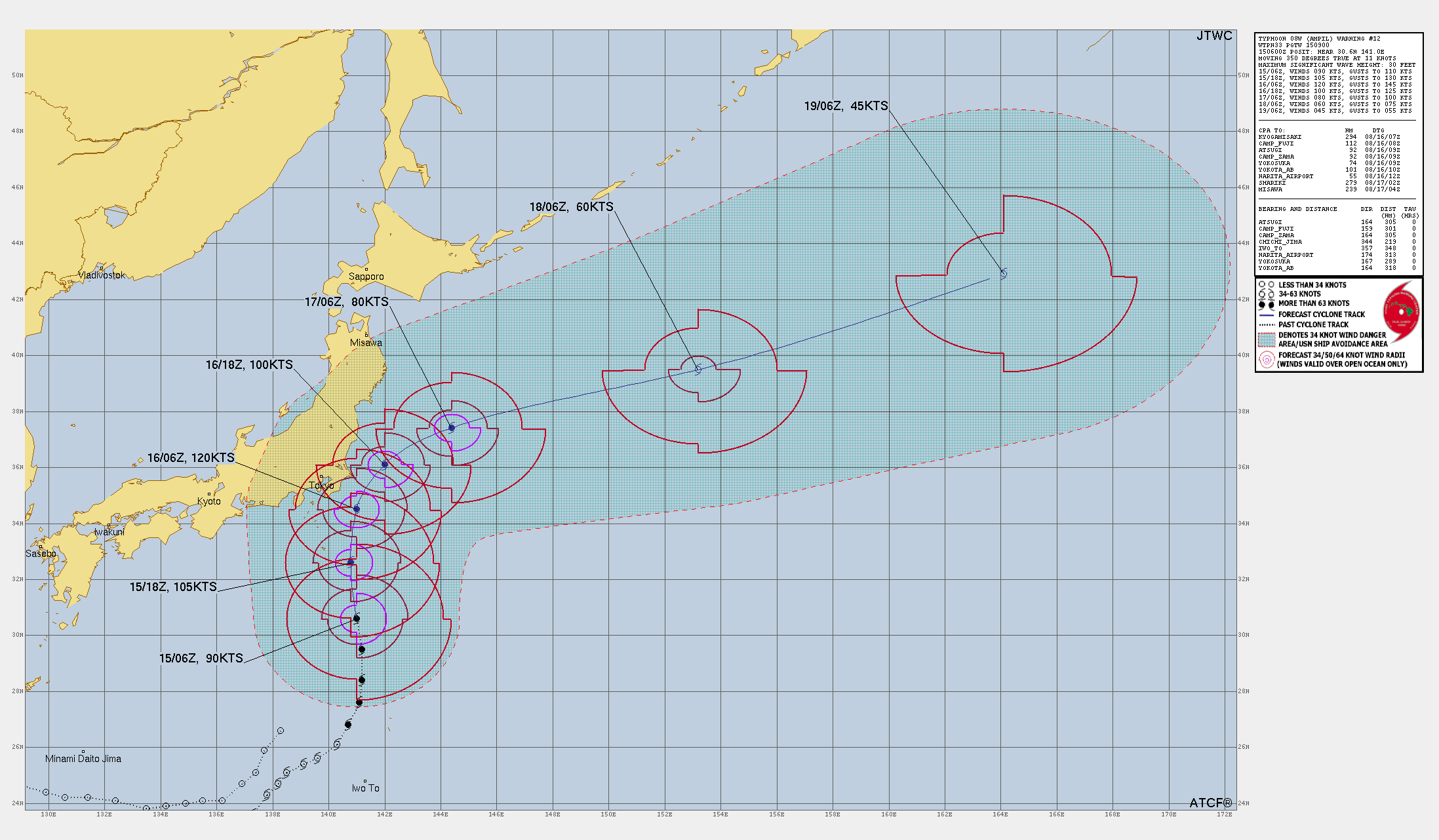
Forecast Track and Intensity of Ampil
Typhoon Ampil is forecast to continue tracking along the western periphery of a subtropical ridge to the east. Around 75 nautical miles southeast of Yokosuka, the storm is expected to begin a northeastward turn as it rounds the ridge. This shift is anticipated near the 24-hour mark.
-
Peak Intensity: Typhoon Ampil is forecast to reach a peak intensity of 120 knots (222 km/h) within the next 24 hours, due to the highly conducive environment.
-
Weakening Trend: After 24 hours, vertical wind shear is expected to increase to around 15-20 knots, and sea surface temperatures are predicted to drop quickly. These factors will initiate a weakening trend, which will continue throughout the forecast period.
By around 60 hours, sea surface temperatures will drop below 25°C, leading to a rapid degradation of the storm. Ampil is expected to complete its extratropical transition near the 96-hour mark, with an intensity of around 45 knots (83 km/h).
Model Guidance and Confidence on the forecast
Numerical model guidance shows strong agreement through the 72-hour mark, with a cross-track spread of just 30 nautical miles at 24 hours as it passes by the Boso Peninsula.
The forecast confidence is high for the track up to 72 hours and medium thereafter. However, the intensity forecast carries medium confidence due to slight discrepancies in model predictions, with some models suggesting rapid intensification while others indicate a more gradual peak.
Previous Typhoon Update: Ex Typhoon Maria Landfall is expected across NE Japan as a weaker storm
Potential Impacts and Preparedness of Ampil
Residents in the affected areas should prepare for the possibility of heavy rainfall, strong winds, and coastal flooding. The storm’s approach will likely bring hazardous conditions to parts of Japan, particularly as it nears the coast.
Maritime activities in the region should be avoided due to the significant wave heights and potential for rough seas.
Typhoon Ampil poses a serious threat as it approaches Japan
Typhoon Ampil poses a serious threat as it approaches Japan, with forecasts indicating rapid intensification and the potential for significant impacts. Monitoring updates and following official guidance will be crucial for ensuring safety as the storm progresses.
If You are in an old update, Check new updates here (Click Me)
Advertisements