Tropical Storm Yagi may Intensify Greatly over South China Sea, Aim Hainan island and Northern Vietnam
Tropical Storm Yagi Update: 11:31 PM Monday, September 2, 2024 (GMT+8) Time in Philippines
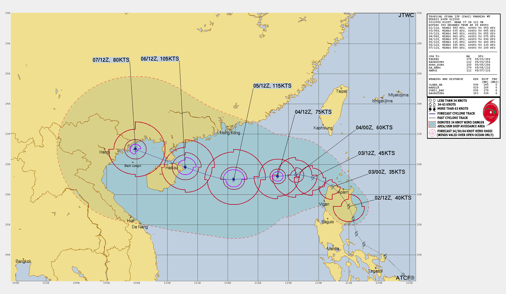
The Joint Typhoon Warning Center (JTWC) has issued its fifth official warning on Tropical Storm Yagi (12W), currently active in the Northwest Pacific. The storm, located north-northeast of Manila, Philippines, is gradually intensifying as it tracks north-northwestward over the northern region of Luzon.
Yagi is poised to intensify further as it moves into the South China Sea, with the potential for rapid intensification in the coming days. Here’s the latest information on Yagi’s position, strength, and forecasted path.
Current Status of Tropical Storm Yagi
As of the latest JTWC warning at 021500Z on September 2, 2024, Tropical Storm Yagi was located near 17.2°N latitude and 122.0°E longitude. The storm has been moving at a steady pace of 8 knots (approximately 15 km/h or 9 mph) in a north-northwest direction, positioning it about 166 nautical miles (307 km) north-northeast of Manila.
The storm currently has maximum sustained winds of 40 knots (74 km/h or 46 mph), with gusts reaching up to 50 knots (93 km/h or 57 mph).
Tropical Storm Yagi’s Wind Distribution and Intensity
The wind distribution of Tropical Storm Yagi highlights its growing strength as it churns over open waters. The radius of 34-knot winds extends 50 nautical miles in the northeast quadrant, 60 nautical miles in the southeast and southwest quadrants, and 30 nautical miles in the northwest quadrant.
Over the next 12 to 24 hours, Yagi is forecast to weaken slightly as it interacts with the mountainous terrain of Luzon but is expected to re-intensify as it moves away from land and enters more favorable conditions in the South China Sea.
Forecast Track and Intensity Predictions for Yagi
Tropical Storm Yagi is expected to continue its northwestward trajectory over the next 24 to 48 hours, gradually turning more westward as it moves into the South China Sea. By 031200Z, the storm will be near 19.1°N latitude and 119.6°E longitude, with its wind speeds predicted to increase to 45 knots (83 km/h or 52 mph), and gusts reaching 55 knots (102 km/h or 63 mph).
As Yagi progresses through the South China Sea, environmental conditions—such as sea surface temperatures of 30-31°C and low vertical wind shear—will support rapid intensification (RI). By 041200Z, Yagi is expected to reach typhoon status with sustained winds of 75 knots (139 km/h or 86 mph), and gusts up to 90 knots (167 km/h or 104 mph).
The storm’s strength will peak around 051200Z, with maximum sustained winds forecast to reach 115 knots (213 km/h or 132 mph), placing it as a Category 4-equivalent storm.
Potential Threats to Hainan and Southern China
Yagi’s potential landfall remains uncertain as the system moves westward. However, current model guidance indicates that the storm may impact Hainan Island and parts of southern China. By 071200Z [20:00 CST (8:00 PM) on September 7, 2024, in China], Yagi is expected to have weakened slightly to 80 knots (148 km/h or 92 mph), with gusts of up to 100 knots (185 km/h or 115 mph), possibly making landfall along the southern China coast or central Vietnam.
The extended outlook shows moderate uncertainty regarding the exact landfall location, with possible tracks extending from central Vietnam to southern China. However, the JTWC predicts that the storm will maintain significant intensity upon landfall, posing serious threats of storm surges, heavy rain, and strong winds to the affected areas.
Environmental Conditions and Rapid Intensification Potential
The forecast predicts a favorable environment for Yagi to undergo rapid intensification (RI) after it clears the northern part of Luzon. Warm sea surface temperatures, low wind shear, and strong outflow into the tropical upper tropospheric trough (TUTT) will contribute to Yagi’s rapid strengthening.
Several models, including HAFS-A and COAMPS-TC, predict that Yagi will peak as a powerful typhoon, with some models showing intensity reaching up to 130 knots (241 km/h or 149 mph). Check for Latest Update to have new Information regarding the Tropical Storm Yagi.
Overall Conclusion of the Forecast Update
As Tropical Storm Yagi continues its journey across the Northwest Pacific, residents in northern Luzon, the Philippines, and those in southern China and Hainan Island should closely monitor the storm’s progress.
Yagi’s rapid intensification and potential landfall pose significant threats to coastal areas, including storm surges, flooding, and damaging winds. Stay updated with local weather advisories and take precautionary measures as necessary.
For more detailed updates, continue following the JTWC’s official warnings and prognostic reasoning on Tropical Storm Yagi (12W).
Advertisements