Tropical Storm Trami to Hit Vietnam Tomorrow (Sunday)
Current Position and Movement as of Tropical Storm Trami Latest Update
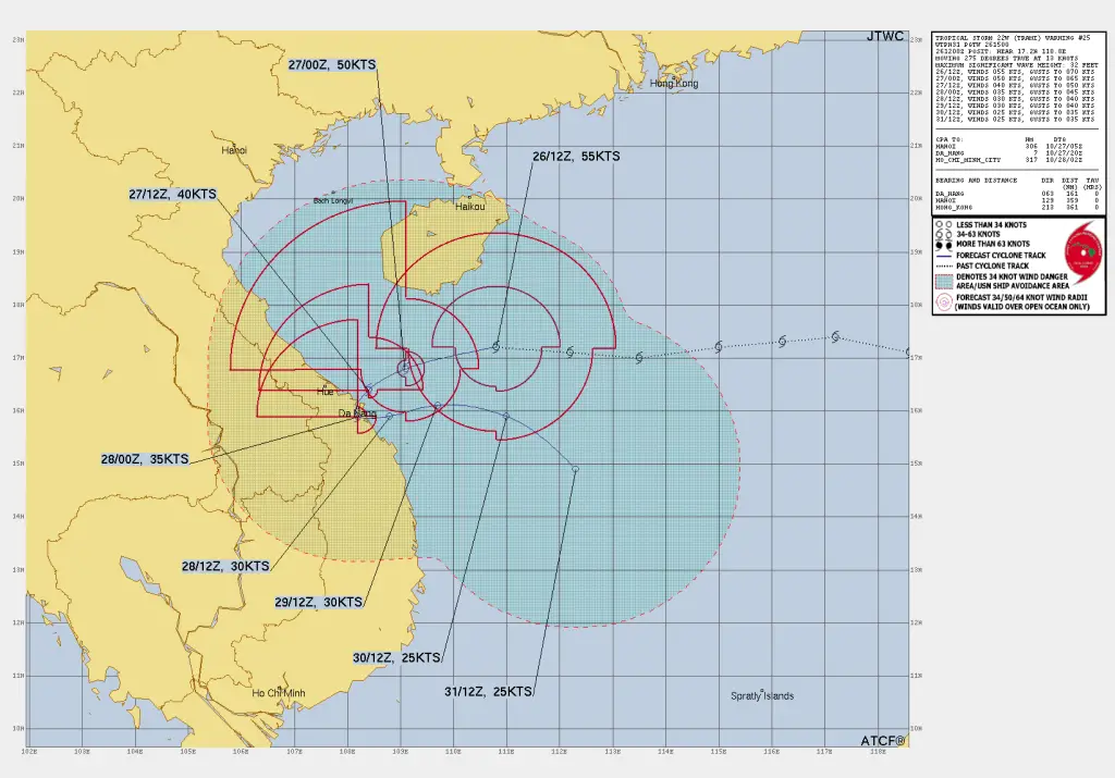
As of October 26, 2024, at 6:00 UTC, Tropical Storm Trami (22W) was positioned near latitude 17.1N and longitude 111.7E, approximately 382 km east-northeast of Da Nang, Vietnam. The storm has been moving westward at a speed of 31 km/h over the past six hours.
Wind Speeds and Current Intensity of Tropical Storm Trami
Tropical Storm Trami’s maximum sustained winds are currently around 101 km/h, with gusts reaching up to 130 km/h. The highest wave heights reported near the storm center are around 31 feet, signaling rough conditions over open water. The storm is expected to gradually weaken as it moves closer to land.
Wind Field Radius and Distribution as of Tropical Storm Trami Latest Update
As of Tropical Storm Trami Latest Update The wind field of Trami is uneven, influenced by vertical wind shear, as stronger winds prevail in the northwest quadrant. The storm’s wind radii are as follows:
- Near Hurricane-Force Winds (101 km/h):
- 102 km in the northwest quadrant
- 102 km in the northeast quadrant
- 102 km in the southeast quadrant
- 139 km in the southwest quadrant
- Tropical-Storm-Force Winds (63 km/h):
- 167 km in the northeast quadrant
- 213 km in the southeast quadrant
- 204 km in the southwest quadrant
- 306 km in the northwest quadrant
Read more:
How to Predict a Tropical Cyclone? Best Tips for Cyclone Prediction
Hurricane Kristy Latest : Weakening Continues
12-Hour Forecast: Continued Westward Track and Weakening
Within the next 12 hours, TS Trami is forecasted to continue its westward track, moving closer to the coast of central Vietnam. By 1800 UTC, it is expected to be positioned near 16.9N, 109.8E with sustained winds decreasing to 93 km/h and gusts to 120 km/h.
24-Hour Forecast: Approach to Vietnam’s Coastline
By October 27, Trami is projected to further weaken, with winds expected to drop to 83 km/h as it nears Vietnam’s coast. Continued high vertical wind shear, along with interaction with the landmass, will likely reduce the storm’s strength.
48-Hour Forecast: Stalling Near Central Vietnam Coast
Trami is likely to slow significantly and may stall near the coast. The weakening subtropical ridge north of Trami, combined with another ridge over the Bay of Bengal, is expected to hinder its westward progression, causing it to remain close to the shore.
Extended Outlook: Dissipation Over Open Water
By 96 hours, the system will likely weaken further, with maximum winds reduced to around 56 km/h. Trami is expected to dissipate as a significant tropical system within the next 5 days due to continued weakening and lack of favorable conditions.
Forecast and Model Discussion as of Tropical Storm Trami Latest Update
Model guidance indicates relatively low confidence in the storm’s track beyond 24 hours due to weakening steering influences. However, it is anticipated that Trami’s intensity will steadily decrease as the system encounters more wind shear and frictional effects from land.
Summary of Expected Conditions
Maximum Sustained Winds: Expected to decrease from 101 km/h to 56 km/h over the next 72 hours.
Direction: Westward for the next 24 hours, followed by stalling near the Vietnamese coast.
Significant Impact: Potential for dangerous surf, coastal flooding, and strong winds along central Vietnam’s coast.
Stay Updated: For residents and officials in Vietnam, continue monitoring local weather updates and advisories, as conditions can change rapidly near the coast
Advertisements


