Typhoon Kong-Rey Latest : Rapid Intensification while approaching Taiwan
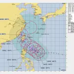
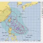
Typhoon Kong-Rey Latest : Issued at 09:00 UTC on October 28, 2024 (JTWC)
As Typhoon Kong-Rey (23W) continues to strengthen and track towards Taiwan, it poses a significant threat to Taiwan, the Ryukyu Islands, and parts of southern Japan. Current projections indicate rapid intensification over the next 48 hours, with strong winds, heavy rain, and high surf likely to impact the region.
Below is a detailed breakdown of the latest forecast information, including the typhoon’s current position, intensity, forecast track, and expected impacts.
Current Position and Movement of Typhoon Kong-Rey as of Latest Update
As of 06:00 UTC on October 28, 2024: Typhoon Kong-Rey
Location: Near 17.8°N, 126.5°E, approximately 519 nautical miles south-southeast of Taipei, Taiwan.
Movement: Tracking west-northwest at 8 knots (15 km/h), with the short-term trajectory expected to maintain this direction.
*//Kong-Rey’s current movement suggests it may continue on a northwest track as it moves into the Philippine Sea, bringing it closer to Taiwan and the Ryukyu Islands over the next 72 hours. Taiwan and southern Japan are within the high-alert zone due to potential changes in the typhoon’s course and intensification//*
Intensity and Wind Field of Typhoon Kong-Rey
Typhoon Kong-Rey Latest update suggests Kong-Rey has intensified into a Category 2 typhoon and continues to gain strength as it moves over warm waters with favorable atmospheric conditions.
Maximum Sustained Winds: 95 knots (176 km/h), with gusts reaching up to 115 knots (213 km/h).
Wind Radii (Extent of Winds):
64-knot Winds: Extending up to 80 nautical miles (nm) in the northeast and northwest quadrants, 50 nm in the southeast quadrant, and 70 nm in the southwest quadrant.
50-knot Winds: Extending up to 115 nm in the northeast and northwest quadrants, 110 nm in the southeast quadrant, and 100 nm in the southwest quadrant.
34-knot Winds: Extending up to 200 nm in the northeast and southwest quadrants and 180 nm in the southeast and northwest quadrants.
Kong-Rey’s well-organized structure and wide wind radii indicate a mature typhoon capable of delivering extensive impacts across a large area.
Forecast Track and Intensity Projections (Next 72 Hours)
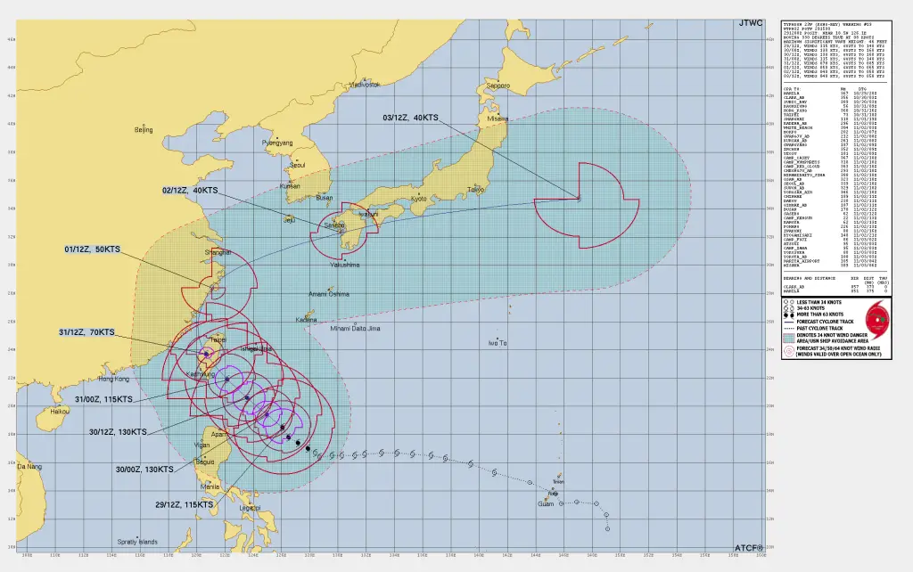
The JTWC forecasts that Kong-Rey will undergo rapid intensification over the next 48 hours, with maximum sustained winds potentially reaching Category 4 strength by October 30. As it nears Taiwan, significant impacts are expected.
12-Hour Forecast (October 28, 18:00 UTC)
- Position: 18.7°N, 125.2°E
- Intensity: 110 knots (204 km/h), gusts up to 135 knots (250 km/h)
- Wind Field: 64-knot winds expected to extend up to 60-70 nm in all quadrants, posing immediate risks to vessels in the region.
24-Hour Forecast (October 29, 06:00 UTC)
- Position: 19.6°N, 124.1°E
- Intensity: 125 knots (231 km/h), gusts up to 150 knots (278 km/h)
- Wind Field: Extended wind reach could impact regions hundreds of kilometers away.
36-Hour Forecast (October 29, 18:00 UTC)
- Position: 20.8°N, 122.7°E
- Intensity: 125 knots (231 km/h), gusts up to 150 knots (278 km/h)
- Wind Field: 64-knot winds reaching up to 70 nm in northeast and southeast quadrants; gale-force winds affecting areas well outside of the immediate storm core.
48-Hour Forecast (October 30, 06:00 UTC)
- Position: 22.6°N, 121.2°E
- Intensity: 115 knots (213 km/h), gusts up to 140 knots (259 km/h)
- Trajectory: Expected to approach southeast Taiwan, likely at peak intensity, bringing intense rainfall and damaging winds to eastern and southern parts of the island.
Read more:
-
Potential Typhoon Kong-Rey Latest : Aiming Taiwan To Bring Disaster
-
Potential Typhoon Kong-Rey (23W) to bring disaster to Taiwan
-
Auckland Weather : Rain to Interrupt Multiple Time This Week
=> How to Predict a Tropical Cyclone? Best Tips for Cyclone Prediction
Extended Outlook and Potential Impacts (72-120 Hours)
Kong-Rey is projected to reach its closest point to Taiwan on October 31, likely maintaining Category 3 strength as it tracks northwestward. Eventually, It may hit Taiwan directly on the same day.
Additionally, the storm’s broad circulation will bring typhoon-force winds, heavy rains, and rough seas to Taiwan, the Ryukyu Islands, and possibly Okinawa.
Forecast Confidence: Rated as medium, with potential track adjustments as Kong-Rey approaches Taiwan due to interactions with surrounding weather systems.
Expected Impacts by Typhoon Kong-Rey :
-
Heavy Rainfall: Kong-Rey’s moisture field could lead to widespread rainfall across Taiwan, particularly in mountainous areas where flash floods and landslides are a high risk.
-
Strong Winds: Typhoon-force winds are expected to impact eastern Taiwan and coastal areas of the Ryukyu Islands, with severe gusts that may result in property damage and power outages.
-
High Waves and Storm Surge: The typhoon will generate high surf and dangerous storm surge conditions along the eastern coastlines of Taiwan, potentially flooding low-lying areas.
Advisory for Residents in The region Surrounding Taiwan
Residents in Taiwan, Okinawa, and southern Japan are urged to stay informed on the latest advisories from local authorities and prepare for possible evacuations. Precautions include securing property, preparing for power outages, and following evacuation orders if issued.
If You are in an old update, Check new updates here (Click Me)
Advertisements

