Typhoon Kong-Rey Latest Update on Forecasted Path, Intensity, and Impacts
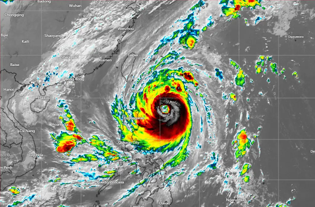
Typhoon Kong-Rey, designated as Typhoon 23W, remains active in the Northwest Pacific, currently tracking near 18.5N, 126.1E as of 12:00 UTC on October 29, 2024. Its position is approximately 472 nautical miles southeast of Taipei, Taiwan.
As of the latest advisory, Kong-Rey is moving north-northwest at 8 knots, with sustained winds of 115 knots (213 km/h) and gusts reaching 140 knots (259 km/h), indicating a highly intense system. The minimum central pressure is estimated at 944 mb, with wave heights in excess of 46 feet.
Current Characteristics and Intensity of Typhoon Kong-Rey
Kong-Rey continues to show strong cyclonic characteristics. Satellite imagery reveals a warming eye, which now measures about 30 nautical miles in diameter, surrounded by a solid eyewall with deep convection spiraling towards the center. This pattern suggests a possible onset of a secondary eyewall formation (SEF) cycle, often associated with a typhoon’s structural change.
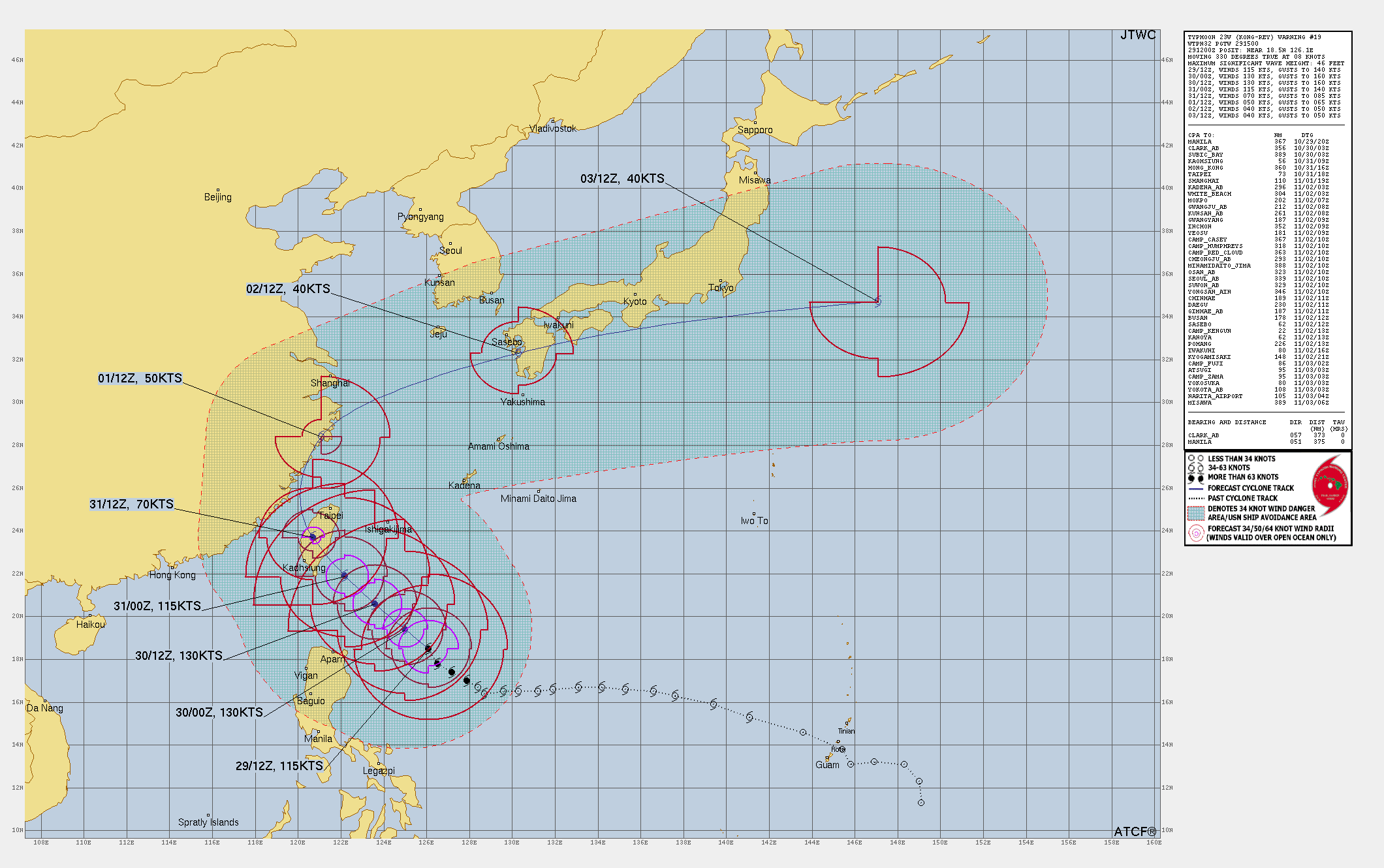
Projected Path and Intensity Changes of the Storm
12-Hour Forecast (October 30, 00:00 UTC): Kong-Rey is expected to intensify, reaching maximum sustained winds of 130 knots (240 km/h) with gusts up to 160 knots (296 km/h). The typhoon will likely continue its north-northwestward path along the southwestern edge of a subtropical ridge (STR) and maintain high intensity as it approaches Taiwan.
24-Hour Forecast (October 30, 12:00 UTC): The typhoon will likely sustain maximum winds of 130 knots (240 km/h) as it nears Taiwan’s southeastern coast, where it may make landfall within 36 to 48 hours. Upon landfall, Kong-Rey’s core will encounter Taiwan’s Central Mountain Range, likely disrupting its structure and intensity.
36-48 Hours (October 31, 00:00 UTC – October 31, 12:00 UTC): Kong-Rey is projected to weaken after crossing Taiwan and entering the Taiwan Strait. Winds will decrease significantly to 70 knots (129 km/h) as it progresses northwestward, with further weakening expected as it approaches the eastern coast of China.
72-Hour Forecast (November 1, 12:00 UTC): Kong-Rey is forecasted to reduce to 50 knots (93 km/h) and undergo extratropical transition as it crosses into the East China Sea. Post-transition, it is expected to pass over Kyushu, Japan, and then move rapidly northeast.
Long-Range Outlook (Up to 120 Hours): By November 3, Kong-Rey will likely fully transition to an extratropical system near 34.7N, 147.1E, impacting southern Japan with gusty winds and rough seas.
Environmental Influences on TY Kong-Rey
Kong-Rey currently benefits from favorable conditions, including low wind shear (5-10 knots), warm sea surface temperatures (29-30°C), and robust radial outflow. However, as the system moves over Taiwan’s mountainous terrain and cooler waters, environmental resistance will weaken Kong-Rey’s intensity. The typhoon will also encounter increasing vertical wind shear and dry air from the north, further accelerating its degradation.
Potential Impacts of Typhoon Kong-rey to Taiwan, China and Japan
- Taiwan: As Kong-Rey moves toward Taiwan, residents should prepare for intense rainfall, high winds, and flash floods. The mountainous topography will exacerbate rainfall, potentially causing landslides.
- China’s Eastern Coast: Although the core of Kong-Rey may avoid a direct hit, it will bring significant rain and gusty winds, especially as it tracks along the coastal areas near Shanghai and the East China Sea.
- Japan: Post-extratropical transition, Kong-Rey will impact Japan’s southern coastlines, bringing heavy rain, rough seas, and gusty winds, particularly in Kyushu and Shikoku.
Read More:
How to Predict a Tropical Cyclone? Best Tips for Cyclone Prediction
Typhoon Kong-Rey Latest : Rapid Intensification while approaching Taiwan
Potential Typhoon Kong-Rey Latest : Aiming Taiwan To Bring Disaster
Confidence Levels and Conclusion of The Forecast
The forecast track remains confident up to 72 hours, especially in Kong-Rey’s approach and impact on Taiwan. However, there is moderate confidence in intensity forecasts due to potential structural changes from secondary eyewall formation. The post-72-hour extratropical phase over Japan introduces uncertainty, with model tracks diverging significantly.
=>If You are in an old update, Check new updates here (Click Me)<=
Advertisements

