Typhoon Kong-Rey Latest Update on Forecasted Path, Intensity, and Impacts as of Wednesday, October 30, 2024 at 15:00 UTC
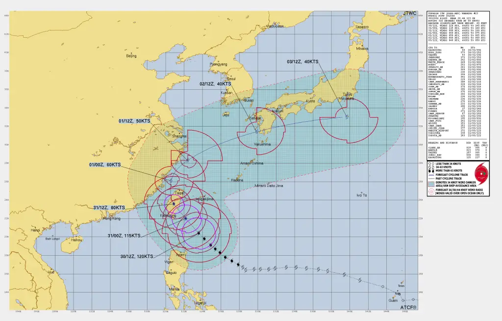
Typhoon Kong-Rey is currently positioned approximately 305 nautical miles (564 km) south-southeast of Taipei, Taiwan, with coordinates at 20.4°N, 123.6°E. It is moving northwestward at a steady pace of 8 knots (15 km/h).
The typhoon’s maximum sustained winds are recorded at 120 knots (222 km/h), with gusts reaching up to 145 knots (269 km/h). The storm’s central pressure has been measured at 934 mb, and it is producing significant wave heights of up to 48 feet (14.6 meters), indicating a powerful storm system with potential impacts in the region.
Current Summary of The Typhoon
Location: Approximately 305 nautical miles (564 km) south-southeast of Taipei, Taiwan
Coordinates: 20.4°N, 123.6°E
Movement: Northwestward at 8 knots (15 km/h)
Maximum Sustained Winds: 120 knots (222 km/h), gusting to 145 knots (269 km/h)
Central Pressure: 934 mb
Significant Wave Height: 48 feet (14.6 meters)
Detailed Forecast and Intensity of the Typhoon Kong-Rey
Typhoon Kong-Rey has reached its peak intensity but is now entering a weakening phase due to an eyewall replacement cycle (ERC). Satellite and radar analysis reveal a clear double eyewall, a classic feature of powerful storms undergoing ERC.
This structural shift is contributing to some weakening in Kong-Rey, but it is also expanding the overall wind field, potentially impacting a larger area of Taiwan as it moves closer to the island.
Forecast Positions and Intensity :
-
12-Hour Forecast
- Position: 22.0°N, 122.2°E
- Wind Speed: 115 knots (213 km/h), gusts to 140 knots (259 km/h)
- Movement: Approaching Taiwan’s coast
-
24-Hour Forecast
- Position: 23.6°N, 120.9°E
- Wind Speed: 80 knots (148 km/h), gusts to 100 knots (185 km/h)
- Impact: Expected to make landfall over Taiwan and cross the island, interacting with mountainous terrain which may further weaken the storm.
-
36-Hour Forecast
- Position: 26.1°N, 120.6°E
- Wind Speed: 60 knots (111 km/h), gusts to 75 knots (139 km/h)
- Impact: Forecast to enter the Taiwan Strait and head northward.
-
48-Hour Forecast
- Position: 28.3°N, 122.4°E
- Wind Speed: 50 knots (93 km/h), gusts to 65 knots (120 km/h)
- Status: Expected to begin extratropical transition as it interacts with a frontal boundary.
-
72-Hour Forecast
- Position: 31.4°N, 129.9°E
- Wind Speed: 40 knots (74 km/h), gusts to 50 knots (93 km/h)
- Status: Extratropical, moving northeastward toward southern Japan.
-
96-Hour Forecast
- Position: 33.0°N, 139.7°E
- Wind Speed: 40 knots (74 km/h), gusts to 50 knots (93 km/h)
- Status: Extratropical, east of Japan.
Read More:
Typhoon Kong-Rey Latest : Rapidly Intensified while approaching Taiwan
Typhoon Kong-Rey Latest : Rapid Intensification while approaching Taiwan
How to Predict a Tropical Cyclone? Best Tips for Cyclone Prediction
Meteorological Analysis of the Devastating Typhoon Kong-Rey:
Typhoon Kong-Rey, while still strong, is showing signs of weakening, particularly in its inner core. The eyewall replacement cycle, a process where an outer eyewall forms and gradually replaces the original inner eyewall, is contributing to the gradual reduction in intensity. Observations suggest a well-defined double-eyewall structure, and warm cloud tops indicate that convection is decreasing within the storm’s central region.
- Environmental Conditions: The storm is situated in a region of low vertical wind shear (5-10 knots), warm sea surface temperatures (28-29°C), and is benefiting from robust poleward and equatorial outflow channels that enhance its structure.
Model Guidance and Uncertainty in the Forecast:
The track forecast remains highly consistent up to 48 hours, with models showing Kong-Rey moving steadily toward Taiwan. As it crosses Taiwan and heads into the Taiwan Strait, Kong-Rey’s movement may become more unpredictable due to its interaction with Taiwan’s terrain and potential decoupling of its core.
Beyond 72 hours, as Kong-Rey undergoes extratropical transition, model divergence increases, particularly in speed and intensity projections, leading to moderate confidence in forecasts beyond the 72-hour mark.
Expected Impacts with Landmass of Taiwan, Eastern China Coast and Japan:
-
Taiwan:
- Landfall Timing: Expected within 18-24 hours
- Impact: Widespread high winds, heavy rainfall, and potential flooding, especially in central mountainous regions. Power outages and infrastructural impacts are likely.
-
Eastern China Coast:
- Impact: Moderate winds and rainfall as Kong-Rey skirts along the coast after Taiwan landfall, with possible coastal flooding and gusty conditions.
-
Southern Japan:
- Impact: As Kong-Rey transitions to an extratropical system, southern Japan may experience gusty winds and heavy rains, especially in mountainous and coastal areas.
=>If You are in an old update, Check new updates here (Click Me)<=
Advertisements


