Latest Update on Typhoon Usagi : Track, Wind Speeds, and Forecast
Typhoon Usagi Update: 09:00 UTC on November 13, 2024
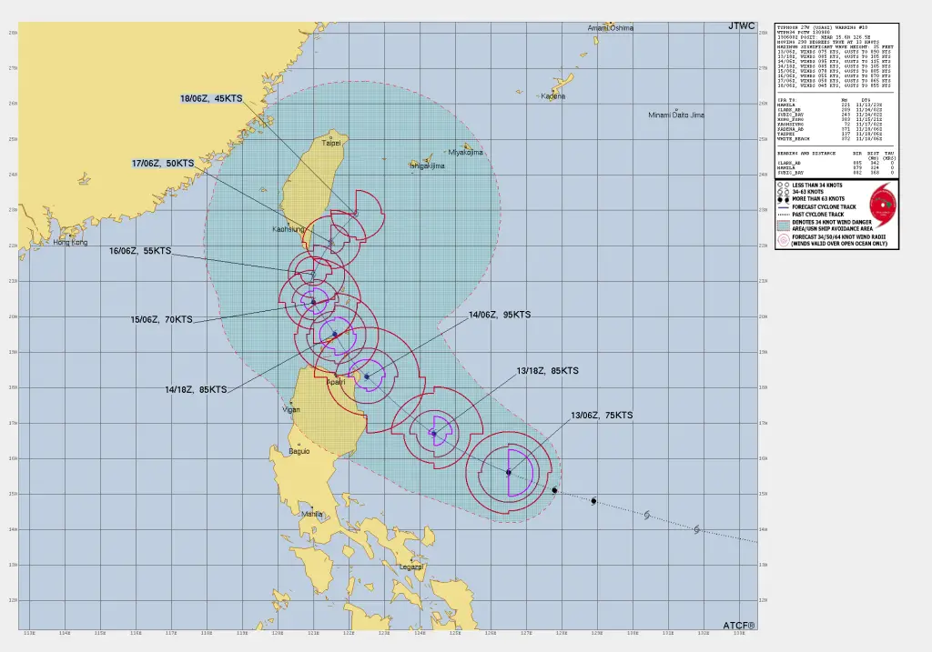
As of the latest reports from JTWC, Typhoon 27W, named Usagi, is currently situated around 324 nautical miles (600 km) east of Manila, Philippines, at approximately 15.6°N, 126.5°E.
The storm is tracking west-northwestward at a speed of 13 knots (24 km/h). Maximum sustained winds are currently at 75 knots (139 km/h) with gusts reaching up to 90 knots (167 km/h). Wave heights in the area are significant, with a peak height recorded at 35 feet (10.7 meters).
Wind Structure of Typhoon Usagi
The typhoon’s wind field is organized as follows:
- 64 KT Wind Radius: 40 nautical miles (74 km) in the northeast and southeast quadrants, while no strong winds in the southwest and northwest quadrants.
- 50 KT Wind Radius: Extends up to 50 nautical miles (93 km) in the northeast, southeast, and southwest quadrants, with 45 nautical miles (83 km) in the northwest quadrant.
- 34 KT Wind Radius: Reaches 70 nautical miles (130 km) in the northeast and northwest quadrants, and 65 nautical miles (120 km) in the southeast and southwest quadrants.
Forecast Movement and Intensity of Typhoon Usagi
Typhoon Usagi is expected to brush the northeastern tip of Luzon within the next 24 hours as it continues on its northwestward path. Afterward, its track becomes uncertain due to various meteorological factors.
“The current forecast projects steady intensification over the next 12 hours, with winds expected to strengthen to around 85 knots (157 km/h) and gusts reaching up to 105 knots (194 km/h) by 1800Z (UTC).”
As the storm continues to move northwestward, it will likely enter the Luzon Strait before encountering cooler waters and increased shear, which may begin to weaken the system beyond 24 hours.
Environmental Factors Impacting Typhoon Usagi
Typhoon Usagi’s progress and strength are currently influenced by favorable conditions, including warm sea surface temperatures (SSTs), low vertical wind shear, and robust upper-level outflow.
However, as the storm moves northward and possibly closer to Taiwan or Japan, it may experience higher shear and reduced oceanic heat content, which could weaken its structure.
Model Forecast Uncertainty on TY Usagi Forecast
Models show extreme uncertainty in Typhoon Usagi’s long-term track and intensity, with significant variability in forecasts from the GFS and ECMWF models.
- ECMWF Forecasts: Project a stronger and larger system skirting the northern Philippines, possibly tracking toward Okinawa.
- GFS Forecasts: Show a weaker, more compact storm impacted by higher shear, potentially moving southwestward over Luzon.
Due to these contrasting scenarios, the track and intensity forecasts beyond 48 hours remain low in confidence.
Long-Term Outlook and Potential Impacts
The Joint Typhoon Warning Center (JTWC) has set a low-confidence forecast for both track and intensity beyond 72 hours. The potential paths range from a recurving scenario that would take Typhoon Usagi northward toward Japan to a weakened system pushing westward into the South China Sea.
Preparedness Recommendations for Potential Impact
Residents in the potential path of Typhoon Usagi, particularly those in the Philippines, Taiwan, and the broader region of the South China Sea, should monitor local weather updates closely and be prepared for potential changes in the storm’s track and strength.
=>If You are in an old update, Check new updates here (Click Me)<=
Advertisements


