Hurricane Flossie Latest Update – July 1, 2025, 6 AM CST
The National Hurricane Center issued Intermediate Advisory Number 9A for Hurricane Flossie at 6 AM CST (1200 UTC) on Tuesday, July 1, 2025. Flossie continues strengthening offshore of southwestern Mexico and is moving west-northwestward away from the coast. Let’s See the detailed forecast as of Hurricane Flossie Latest Update:
Current Location & Movement
-
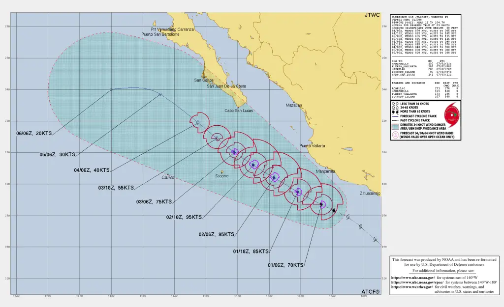
Coordinates: 17.1° N, 105.6° W
-
Distance to Land: ~250 km (155 mi) south-southwest of Manzanillo, Mexico
-
Present Motion: West-northwest at 17 km/h (10 mph)
-
Central Pressure: 979 mb (28.91 inches)
Current Intensity as of Hurricane Flossie Latest Update
-
Maximum Sustained Winds: 145 km/h (90 mph)
-
Gusts: Higher than 145 km/h
-
Wind Radii:
-
Hurricane-force (≥ 119 km/h): up to 30 km (15 mi) from center
-
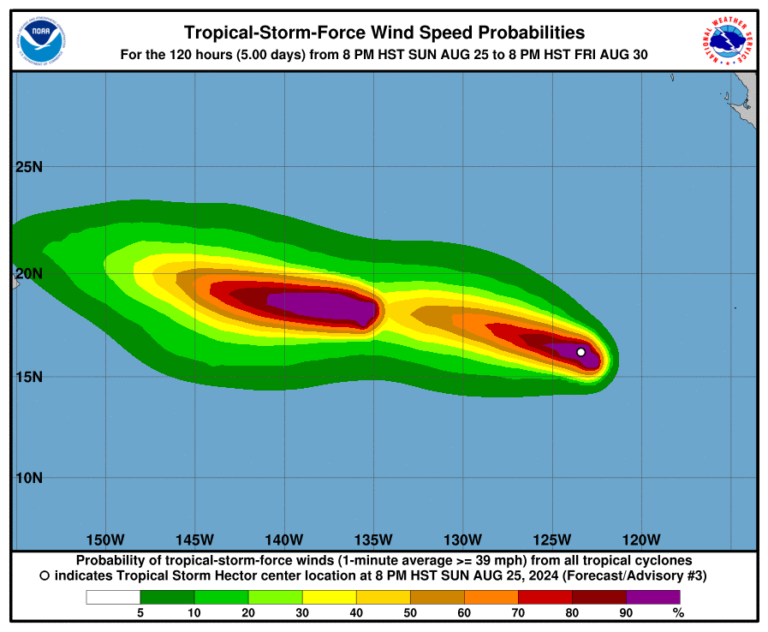
Tropical-storm-force (≥ 63 km/h): up to 150 km (90 mi) from center
-
Flossie is forecast to continue strengthening over the next 24–36 hours, potentially peaking as a major hurricane before weakening by late Wednesday.
Watches & Warnings as of Hurricane Flossie Latest Update
-
Tropical Storm Warning (gusty tropical-storm conditions expected within 36 hours):
• Punta San Telmo to Playa Perula -
Tropical Storm Watch (tropical-storm conditions possible within 48 hours):
• East of Punta San Telmo to Zihuatanejo
• North of Playa Perula to Cabo Corrientes
Residents elsewhere in southwestern Mexico should continue monitoring Flossie’s progress and heed local advisories.
Hazards as of Hurricane Flossie Latest Update
Heavy Rainfall
-
Forecast totals: 50–100 mm (2–4 in), isolated peaks up to 150 mm (6 in)
-
Areas at risk: Guerrero, Michoacán, Colima, and Jalisco
-
Impacts: Isolated life-threatening flooding and mudslides in steep terrain
Wind
-
Tropical storm conditions expected within warning areas through this morning
-
Possible gusts to hurricane strength near the core
Dangerous Surf & Rip Currents
-
Swells will persist along the southwestern Mexican coast for several days
-
Life-threatening surf and rip currents likely — consult local forecasts
What’s Next as of Hurricane Flossie Latest Update?
Flossie’s track keeps it moving off-shore today, sparing coastal areas from direct landfall. However, dangerous surf, flooding rain, and strong gusts will continue to impact the watch/warning zones through mid-week.
A gradual weakening trend is expected by Wednesday as Flossie moves into cooler waters and experiences increased wind shear.
For the latest rainfall graphics here, Click
Forecaster: Beven
Source: NHC Intermediate Advisory 9A
Stay tuned to the National Hurricane Center and local meteorological services for further updates.
If You are in an old update, Check new updates here (Click Me)
Advertisements