Tropical Storm Danas Update – July 5, 2025, 9 AM UTC
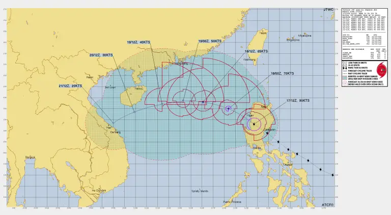
The Joint Typhoon Warning Center (JTWC) has released Prognostic Reasoning Warning Number 6 for Tropical Storm 05W (Danas) as of 9 AM UTC, July 5, 2025. Danas remains a strengthening tropical storm east-southeast of Hong Kong, moving slowly as it intensifies over very warm waters as of Tropical Storm Danas latest Update.
Current Location and Movement
-
Location: 20.5°N, 117.9°E
-
Distance: About 432 km east-southeast of Hong Kong
-
Recent Movement: Northeast at 6 km/h over the past 6 hours
-
Significant Wave Height: 5.2 meters
Current Intensity and Environmental Conditions as of Tropical Storm Danas latest Update
-
Maximum Sustained Winds: 102 km/h (equivalent to 55 knots)
-
Wind Gusts Detected: Up to 113 km/h (59–61 knots) in the eastern band
-
Sea Surface Temperature: 29–30°C — highly favorable for further strengthening
-
Vertical Wind Shear: Low (19–28 km/h)
-
Outflow: Strong radial outflow supports intensification
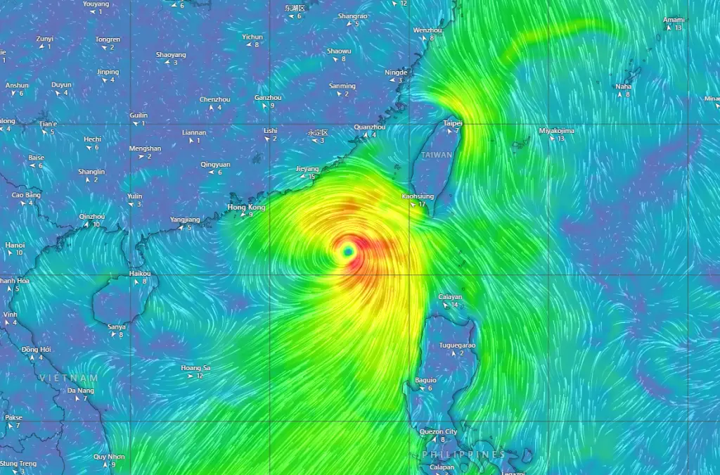
Recent satellite and microwave imagery show robust deep convective bands extending up to 300 km from the center. The low-level circulation center (LLCC) is fully obscured by dense convection, but microwave passes confirm a well-organized structure.
Steering Factors as of Tropical Storm Danas Update
Danas is currently embedded in a competing steering pattern, influenced by:
-
A Subtropical Ridge (STR) to the north, and
-
A Near-Equatorial Ridge (NER) building to the southeast.
This is slowing Danas’s forward speed while it drifts northeastward toward the Taiwan Strait.
Forecast Track and Intensity Outlook as of Tropical Storm Danas Latest Update
Expected Path (Next 48 Hours)
-
Danas will continue northeastward at a slow pace (~6 km/h), steered by the surrounding ridges.
-
The NER is expected to strengthen, helping guide Danas into the Taiwan Strait.
-
By 72 hours, the steering ridges will shift, likely forcing Danas to turn westward toward mainland China.
Possible Rapid Intensification
-
Environmental conditions are highly favorable for intensification: warm SSTs near 30°C, strong outflow, and low wind shear.
-
Multiple models and rapid intensification aids suggest Danas could strengthen quickly over the next 24–48 hours.
-
Once Danas approaches land, terrain interaction will cause rapid weakening.
Final Landfall and Dissipation
-
A westward turn into mainland China is expected by day 3–4, with full dissipation likely by day 4 (TAU 96).
-
Forecast intensity could peak before land interaction, then quickly drop below tropical storm strength.
Model Guidance and Confidence as of Tropical Storm Danas latest Update
-
Track Confidence: Medium through 72 hours due to the competing ridges and low translation speed.
-
Intensity Confidence: Medium, as there is uncertainty in peak strength but good agreement on rapid weakening once over land.
-
Models show a spread of 100–200 km in possible track outcomes, especially near the Taiwan Strait.
✅ Key Points to Monitor
✅ Current Winds: 102 km/h
✅ Possible Peak: Rapid intensification possible over next 24–48 hours
✅ Track: Northeastward into Taiwan Strait, then westward turn toward mainland China
✅ Hazards: Heavy rain, high winds, rough seas, and significant wave heights over 5 meters
⚠️ Who Should Watch This Storm?
-
Mariners in the Taiwan Strait and South China Sea
-
Coastal residents in southern Taiwan and southeastern China
-
Interests near Hong Kong should monitor for any westward deviations
⏰ Update Time: July 5, 2025, 9 AM UTC
Source: JTWC Prognostic Reasoning for Tropical Storm Danas (Warning NR 006)
Stay alert for official forecasts and advisories from your local meteorological agencies.
If You are in an old update, Check new updates here (Click Me)
Advertisements