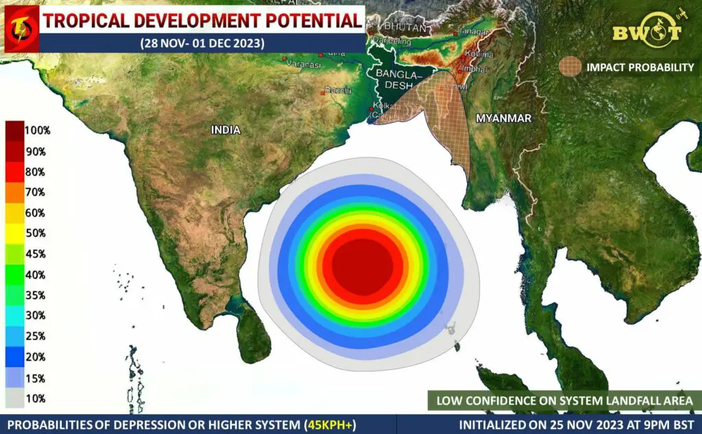
SPECIAL WEATHER UPDATE | DATE: 26 NOVEMBER 2023 | TIME: 09:30AM BST (+6 GMT) | SUB: TROPICAL DEVELOPMENT POTENTIAL | PERIOD: 28 NOV- 01 DEC 2023
.
Under the influence of a Disturbance (Invest 99W), a Low Pressure Area is likely to develop over the southeast Bay of Bengal and adjoining South Andaman Sea by 27-28th Nov 2023.
BWOT’s analysis through multi-source’s information indicates that the system is likely to intensify into a Well Marked LPA and Depression by 28-29th November and become a Deep Depression and subsequently a Cyclonic Storm by 30th November. There is a probability of intensification into a strong Tropical Cyclone (hurricane category 1) due to relatively very favorable environment over the suspect region.
.
▪️️ Global models indicate the probability of a Low Pressure Area formation over south Andaman Sea and southeast Bay of Bengal by 27-28 Nov and possible intensification into a Depression, Deep Depression and Cyclonic Storm over South Central parts of Bay of Bengal during 29-30 November. Few of them are also indicating more intensification up to hurricane category 1 throughout the forecast period. Most of them are also indicating landfall between Barishal to Myanmar coast between 3-7th December 2023. However, There is a large variation in model forecast in respect of landfall time, area and intensity.
.
◾ LANDFALL AND MAXIMUM INTENSITY:-
Although there is high uncertainty in the landfall location, It may strike as a strong Cyclone around 4-5th December anywhere between Southern Bangladesh to Western Myanmar coast (would be more specific after formation). The maximum intensity of the storm is skeptical right now. But, Environmental condition supports intensification up to 100-150kph(~1min) during the forecast period.
.
⚠️EFFECTS:-
Due to the direct impact of the potential system, Mostly South Eastern Bangladesh and Western Myanmar to witness moderate to very heavy rain/showers between 02 -05 December 2023. Heavy to very heavy rains may occur at various places near the landfall region. Rainfall activity may reduce or increase along with the change of the system track.
•Sea may be very rough to extremely rough across the Central to Northern Bay of Bengal during 29 Nov- 4/5 Dec. And gusty winds of 100-150 kmph may occur across the landfall area around 4-5th Dec 2023.
☔RAINFALL:-
Due to the direct impact of the potential system, Mostly South Eastern Bangladesh and Western Myanmar to witness moderate to very heavy rain/showers between 02 -05 December 2023. Heavy to very heavy rains may occur at various places near the landfall region. Rainfall activity may reduce or increase along with the change of the system track.
*NB: This forecast includes Rainfall Activity only by direct influence of the Tropical system, which is based on the probable track. It could be changed if the track changes!
Sources/Resources used in this analysis: CFS, GFS, ECMWF, CMC, ACCESS-G, NAVGEM, JMA, UKMET, HWRF, IMD GFS, Meteo France Models, Himawari 8 Satellite, EWP, ER, CCKW, 200hPa VP, 850hpa Vorticity, 500hPa Vorticity, STR, 200hpa Winds, Sea Surface Temperature, OLR, WWB, EWB, Synoptic Chart, Vertical Wind Shear, IMD Forecast, BMD Forecast.
.
★NOTE:-
This information is based on present conditions & it might be changed somewhere during the entire forecast period. Don’t make any decision based on this update. Seek official information.
Keep eye on the latest update for better information.
=>
Stay connected, Stay alert, Stay Safe.
Best regards, ©Bangladesh Weather Observation Team (BWOT).

Advertisements


