Latest Update on Tropical Cyclone 10S (Tropical Low 11U) Near Northwest Australia
As of January 18, 2025, Tropical Cyclone 10S continues to develop off the northwest coast of Australia. Here’s a detailed analysis of its current status, trajectory, and potential impacts.
Current Status of Tropical Cyclone 10S (Tropical Low 11U)
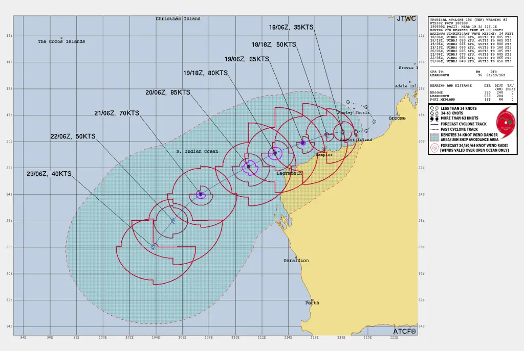
Location: 19.3°S, 118.1°E (Approximately 66 nautical miles north-northwest of Port Hedland, Australia).
Movement: Westward at 9 knots over the past six hours.
Maximum Sustained Winds: 35 knots (65 km/h) with gusts up to 45 knots (85 km/h).
Minimum Central Pressure: 996 mb
Wave Height: Maximum significant wave height at 14 feet.
Forecast and Expected Trajectory of Tropical Cyclone 10S (Tropical Low 11U)
Short-Term Projections (Next 48 Hours):
Intensity: Rapid intensification is expected due to highly favorable environmental conditions, including warm sea surface temperatures (29-30°C), low vertical wind shear (0-5 knots), and moderate radial outflow.
Track: Cyclone 10S is forecast to shift west-southwest and later southwest along the northwest periphery of a subtropical ridge to the southeast.
Wind Speeds:
-
-
12 hours: Expected maximum sustained winds of 50 knots (93 km/h).
-
24 hours: Expected maximum sustained winds of 65 knots (120 km/h).
-
48 hours: Peak intensity forecast at 85 knots (157 km/h).
-
Extended Outlook (72 to 120 Hours):
Cooling Waters and Weakening: Beyond 48 hours, cooler sea surface temperatures, increased wind shear, and dry air intrusion will weaken the cyclone, reducing wind speeds to 40 knots (74 km/h) by 120 hours.
Track Confidence: High confidence for the initial 72-hour track. Medium confidence beyond 72 hours due to increased model spread.
Potential Cyclone Impacts on Northwest Australia
Coastal Areas:
-
-
The system poses a threat to coastal regions of northwestern Australia, especially near Port Hedland.
-
Heavy rain and strong winds may result in localized flooding and power disruptions.
-
Marine Conditions:
-
-
Hazardous seas with wave heights up to 14 feet.
-
Dangerous conditions for maritime operations in the region.
-
FAQs on Tropical Cyclone 10S (Tropical Low 11U)
What is the current intensity of Tropical Cyclone 10S?
Tropical Cyclone 10S is currently at 35 knots (65 km/h) sustained winds, with gusts reaching 45 knots (85 km/h).
Where is Tropical Cyclone 10S headed?
The cyclone is moving west-southwest and is expected to shift southwestward around the subtropical ridge.
Will Tropical Cyclone 10S make landfall?
As of now, the system is tracking offshore, but its proximity to the northwest coast of Australia may bring indirect impacts such as rain, strong winds, and hazardous seas.
When will Tropical Cyclone 10S weaken?
The cyclone is expected to reach peak intensity within 48 hours and then gradually weaken as it encounters less favorable conditions.
For the latest forecasts and warnings, monitor updates from the Australian Bureau of Meteorology and the Joint Typhoon Warning Center. Ensure preparedness measures are in place if you reside in or near the affected areas.
If You are in an old update, Check new updates here (Click Me)
Advertisements


