NOTE: HIGH CONFIDENCE ON THIS FORECAST!!
UPDATE 2/ LOW PRESSURE AREA(LPA) | DATE: 18 AUGUST 2023 | DAY: FRIDAY | TIME: 8:25AM BST (+6 GMT)
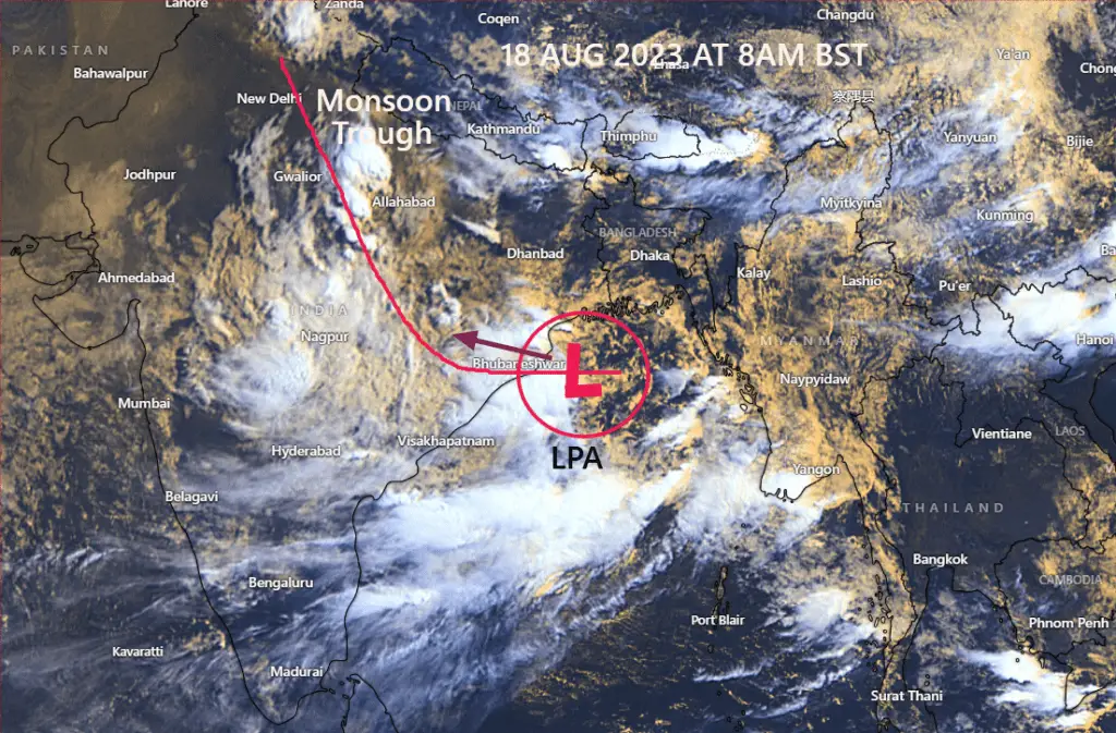
The Low Pressure Area(LPA) over North Bay of Bengal and adjoining areas has moved further west-northwestward. Which continued to form deep convective clouds over the northwest Bay of Bengal. The main influence of the low pressure has extended to North Bay of Bengal. Due to which the entire North Bay of Bengal is slightly rough.
★Maximum Wind (1 minute sustained):-
Average maximum wind speed at 50 km radius from the low level center is 30 km/h at 8 am today increasing to 45 km/h with gusts.
★Dynamic Analysis:-
Upper level analysis indicates that the system is currently in a fairly unfavorable environment due to high VWS (45kt+), moderate outflow, favorable SST (29-30°C), some well-structured low level vorticity, mixing of moisture supply and few relevant atmospheric parameters. Mainly because the wind shear has increased tremendously, the environment has become unfavourable.
• Due to the above mentioned conditions, it is not likely to intensify further. It may gradually weaken as it crosses Odisha coast tonight.
•According to the atmospheric conditions mentioned above, the system has already attained a maximum speed of 30kph(~1min), increasing to 45km/h with gusts.
★Movement:-
It has moved towards West North West at an average speed of 22 km/h during the last 6 hours.
*From its current location, it may move in an average west-northwest direction.
★Landfall:-
It is likely to cross Odisha coast as a Low Pressure Area(LPA) during afternoon to night today. And may then merge with the monsoon trough.
★ Warning:-
Under the influence of the system, gusty winds of 30 to 50 km are blowing in the North Bay of Bengal. Due to which the sea is somewhat rough. So it is better to move with measures according to the situation.
★Suggestion:-
Fishermen and small boats are advised not to venture into the deep sea for the next two days. The potential for danger remains in deep-sea excursions. And those at sea are safer to navigate near the coast.
★Rainfall:-
Due to the direct impact of the system, there is a possibility of substantial rainfall over East Central India including Odisha, Chhattisgarh, India during the next 3/4 days. However, no sign of heavy rainfall was found in Bangladesh except for scattered rains. On the contrary, there is a possibility of some more thundershowers in the eastern part of the country especially in the northern part of Chittagong division and Sylhet division every evening or night for the next 2/3 days. Apart from this, there may be scattered thundershowers in other parts of the country.
.
★Note: This information may change slightly. So, check new updates for better information!
Components used in this analysis: Global Model, Himawari 9 Satellite, 200hPa VP, 850hpa Vorticity, 500hPa Vorticity, Sea Surface Temperature, MJO, Synoptic Chart, Wind Shear, Subtropical Ridge.
=>
Please share as much as you can.
Stay tuned for next update!
Thanks, ©Bangladesh Weather Observation Team (BWOT)
Advertisements
