Cyclone Lincoln: Severe Weather Warning for NT and Kimberley region of Australia
Cyclone Update: 18 Feb at 05:50 pm AEST(GMT+10hrs), 7:50 am GMT, 01:50pm BST(GMT+6hrs)
Ex-Tropical Cyclone Lincoln currently positioned over the center of the Northern Territory. It poses a significant threat as it moves westward towards the Kimberley region.
The impending weather system is expected to bring heavy rainfall, strong winds, and the potential for flash flooding across Mid-Western NT and Kimberley region. Prompting authorities to issue severe weather warnings across the affected areas.
Heavy Rainfall and Flash Flooding in Kimberly, adjoining Mid-western NT
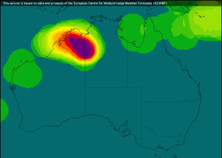
Southeastern parts of the Kimberley district are forecasted to experience heavy rainfall from Monday early morning onwards.
Six-hourly rainfall totals ranging between 60 and 100 mm along with 24-hourly totals between 80 and 140 mm are anticipated.
Additionally, there is a risk of locally intense rainfall later on Monday evening. Due to six-hourly totals potentially reaching up to 150 mm, dangerous and life-threatening flash flooding is very likely.
Rest of Kimberly region, specially middle to northern parts to have massive rainfall during next 3 days. It is most likely to start from tomorrow. It may lead to flash flooding or water logging there. So, Cyclone Lincoln is carrying a Severe Weather Warning for those regions.
Rainfall forecast of Australia for next 3 days: ECMWF Model
See More: Cyclone Lincoln: Potential for Regeneration
More info: Ex-TC Lincoln: Massive Rainfall in Northern Australia
Deeper: Ex-Tropical Cyclone Lincoln: Redevelopment Possible
Strong Winds and Damaging Gusts induced by Ex TC Lincoln
In addition to heavy rainfall, strong winds averaging between 50 to 60 km/h, with damaging gusts of about 90 km/h, are possible across
- Broome District
- Derby-West Kimberley District
- East Kimberley District
- Wyndham-East Kimberley District
- Halls Creek District
Thunderstorms accompanied by temporary gusts may affect across wider area. These conditions heighten the risk of property damage and pose dangers to outdoor activities.
New Video Forecast:
Severe Weather Expansion across Kimberly
The impact of severe weather is expected to expand further into northern parts of the Kimberley on Tuesday and Wednesday. Which reflects the existing risks associated with Ex-Tropical Cyclone Lincoln.
Precautionary Measures to Follow
Authorities have issued precautionary advice to residents and communities in affected areas to ensure their safety:
*Seek safe shelter away from trees, power lines, and stormwater drains if outdoors.
*Stay indoors, away from windows, and close curtains and blinds.
*Unplug electrical appliances and avoid using landline telephones during lightning storms.
*Refrain from boating, swimming, or surfing, and remain vigilant for hazards on roads.
*Avoid flooded drains, rivers, streams, and waterways, and be cautious of fallen trees and debris.
*Treat fallen power lines as live and keep a safe distance.
*Assess any damage to property and contact insurance companies for necessary repairs.
*Call emergency services (SES) if significant damage occurs, such as a badly damaged roof or flooding.
Summary
As Ex-Tropical Cyclone Lincoln progresses westward towards the Kimberley, residents are urged to stay informed, prepared, and vigilant.
Adherence to safety guidelines and proactive measures can mitigate risks and ensure the well-being of individuals and communities amidst the impending severe weather conditions.
Advertisements