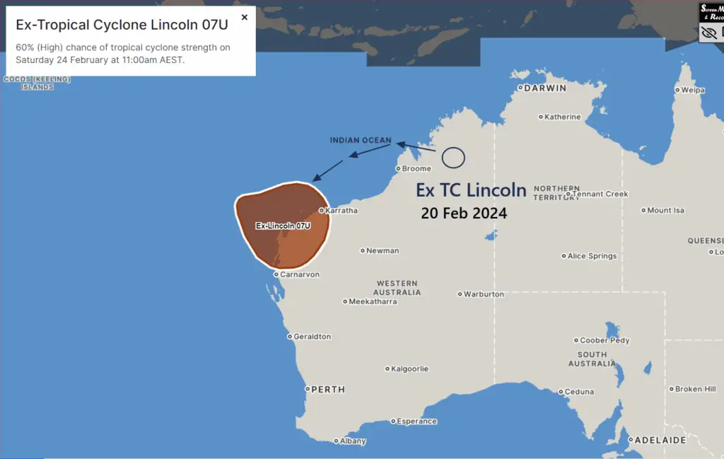
Cyclone Lincoln: All set to Re-intensify into a Tropical cyclone Thursday
Ex-Tropical Cyclone Lincoln (07U) is currently making its way westward across the Kimberley region, along with bringing heavy rainfall to nearby areas.
Cyclone Lincoln is all set to Re-intensify as it falls over open water Wednesday. It is currently a Tropical Depression overland.
Forecast and Development of Cyclone Lincoln
From Wednesday, Lincoln is expected to approach waters west of the Kimberley and north of the Pilbara. There is a significant risk that it may redevelop into a Tropical Cyclone by Thursday.
Meteorologists warn of a potential intensification into a severe tropical cyclone, posing increased risks to affected regions across Western Australia.
48 hrs Impact area of Ex TC Lincoln: ECMWF Model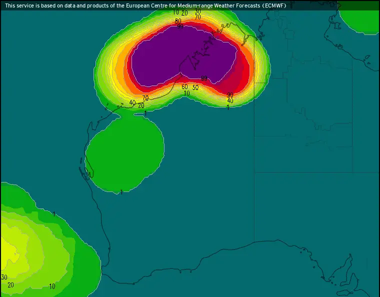
Potential Impact of Cyclone Lincoln over WA
Residents are advised to remain alert as Lincoln could potentially move towards the west Pilbara coast by late Friday or Saturday. This movement could result in adverse weather conditions along the coast, requiring precautionary measures and preparedness.
Landfall and Weakening Over Land
By Sunday, forecasters anticipate Ex-Tropical Cyclone Lincoln to weaken as it moves further inland. Despite this weakening trend, residual effects may still be felt in certain areas, emphasizing the importance of continued monitoring।
Concerns Regarding Potential Cyclone Impact
Initial Observations:
As the potential cyclone traverses over sparsely populated plains, concerns initially seem minimal. The area it currently traverses has low population density, potentially reducing immediate risks to communities.
Rising Concerns of 2nd Landfall:
However, as the cyclone moves into water and gains intensity, the situation could escalate. There’s a significant concern about its potential landfall around the Onslow , Exmouth and Coral Bay region by 23-24th February.
If the cyclone reaches peak intensity upon reaching the coast, residential areas could face substantial risks. Additionally, industrial projects in the vicinity may suffer damages, further exacerbating the impact.
See Also: Cyclone Lincoln: May Re-intensify Wednesday off Kimberley Coast
See More: Mauritius Weather: Tropical Cyclone 16S to Pose a Risk of Landfall
Useful 7 days Weather: NSW Weather: Severe Thunderstorm Warning for Multiple NSW Districts
What to do?
While the current trajectory may not immediately pose severe threats, vigilance is crucial as the cyclone’s path evolves.
As It approaches the coast and potentially intensifies, heightened precautionary measures are warranted to mitigate potential damages and ensure the safety of affected communities.
Residents in potentially affected areas by should keep an eye on weather forecasts and advisories to stay informed.
By remaining informed and prepared, communities can better mitigate the potential impacts of this weather event.
Advertisements