Tropical Storm Krathon Update over North West Pacific May Aim Taiwan
Krathon Update: 8:18 PM Saturday, September 28, 2024 (GMT+8) Time in Taiwan
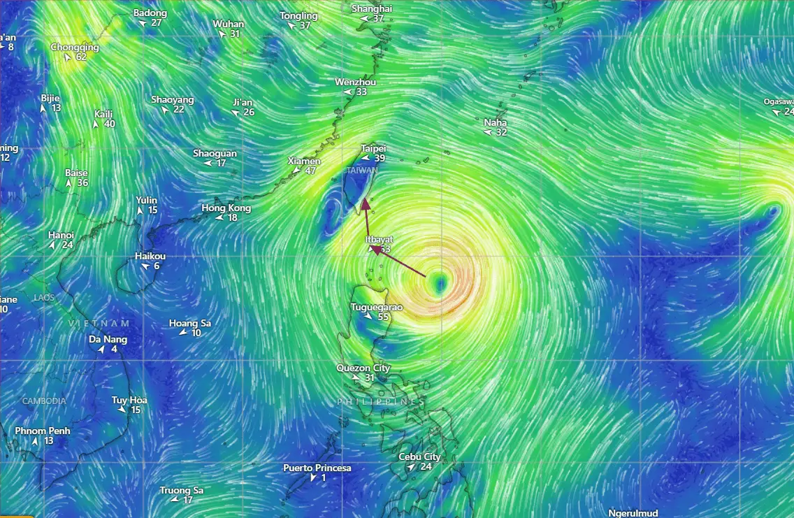
As of 9:00 AM UTC on September 28, 2024, Tropical Storm Krathon (TS 20W) is continuing to gain strength in the Northwest Pacific. Located near 18.5N 125.6E, approximately 495 nautical miles south-southwest of Kadena Air Base, the storm has sustained winds of 35 knots (65 km/h), with gusts up to 45 knots (85 km/h). The storm is moving slowly southwestward at 5 knots over the past six hours.
Current Conditions As of Tropical Storm Krathon Latest Update
Location: 18.5N 125.6E
Maximum Sustained Winds: 35 knots (65 km/h)
Gusts: 45 knots (85 km/h)
Minimum Central Pressure: 997 mb
Wave Height: 16 feet
Wind Distribution of TS Krathon
Tropical storm force winds extend up to 110 nautical miles in the southwest quadrant and 80 nautical miles in the southeast quadrant. Wind coverage is much more limited in the northern quadrants, with only 10 nautical miles of storm-force winds in the northeast and northwest regions.
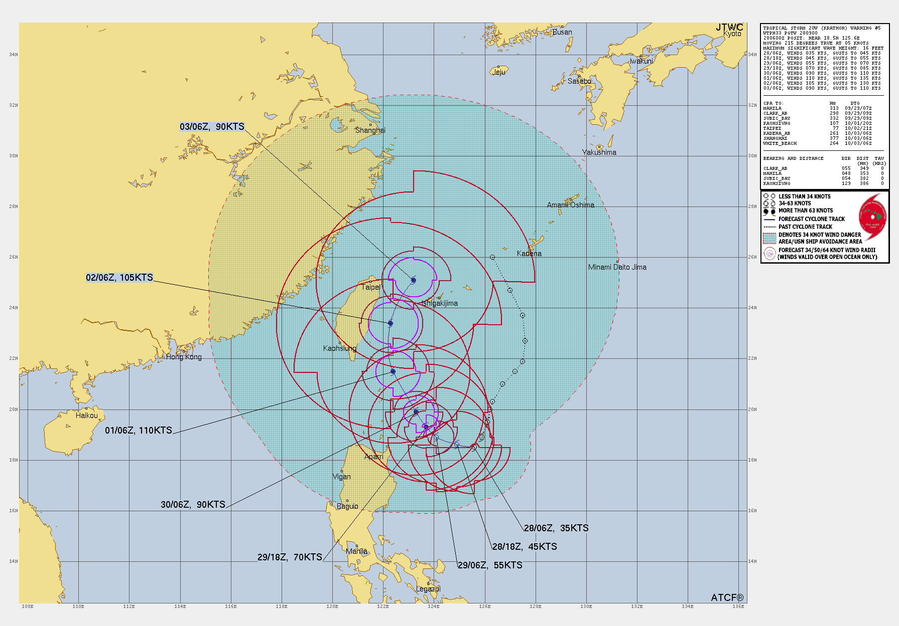
Forecast Discussion as of Tropical Storm Krathon Update
Over the next 24 to 72 hours, Krathon is expected to continue strengthening as it moves slowly westward, then curving northward. The subtropical ridge to the northeast will likely guide the storm, turning it toward Taiwan’s eastern coast by September 30 or October 1.
Krathon will experience favorable environmental conditions for intensification, including:
Low Vertical Wind Shear: 5-10 knots
Warm Sea Surface Temperatures: 29-30°C
Moderate Outflow: Equatorward outflow will help Krathon maintain its intensity as it moves northward.
Forecasted Intensities:
- 12 Hours (Valid at 1800 UTC 28 September): 45 knots (85 km/h), with gusts to 55 knots (100 km/h).
- 24 Hours (Valid at 0600 UTC 29 September): 55 knots (100 km/h), with gusts to 70 knots (130 km/h).
- 36 Hours: Rapid intensification is expected, with winds increasing to 70 knots (130 km/h), gusting to 85 knots (155 km/h).
- 48 Hours (Valid at 0600 UTC 30 September): Maximum sustained winds of 90 knots (165 km/h), gusting up to 110 knots (205 km/h).
“By 72 hours (October 1), the storm may reach Category 3 intensity, with winds up to 110 knots (205 km/h), especially as it approaches Taiwan’s eastern coastline.”
Long-Term Outlook of Tropical Storm Krathon Update
Day 4-5 (October 2-3): Krathon is forecasted to peak near 105 knots (195 km/h) but may weaken slightly due to land interaction as it skirts Taiwan.
Vertical wind shear will also begin to increase, leading to a gradual weakening by October 3. The storm is expected to weaken to 90 knots (165 km/h).
Potential Impact on Taiwan by Tropical Storm Krathon
Krathon’s forecast track remains uncertain, with models showing a wide range of possible landfalls. The system may come close to the eastern coast of Taiwan, bringing:
- Heavy Rainfall: Significant rainfall and potential for flooding.
- Strong Winds: Potential hurricane-force winds near the coast, with higher gusts in elevated terrain.
- Storm Surge: Coastal areas may experience significant storm surge, especially in low-lying regions.
Conclusion of The Tropical Storm Krathon Update
Tropical Storm Krathon is rapidly intensifying in the Northwest Pacific, with a high likelihood of becoming a significant typhoon over the next 48 to 72 hours. Residents in Taiwan and nearby coastal areas should closely monitor updates and prepare for possible impacts by the beginning of October.
For Latest updates, visit Global Weather.
Advertisements