NB: High Confidence on this forecast track!!
UPDATE 2/WELL MARKED LPA(92B) | DATE: 21 OCT 2023 | DAY: SATURDAY | TIME: 03:00PM BST (+6 GMT)
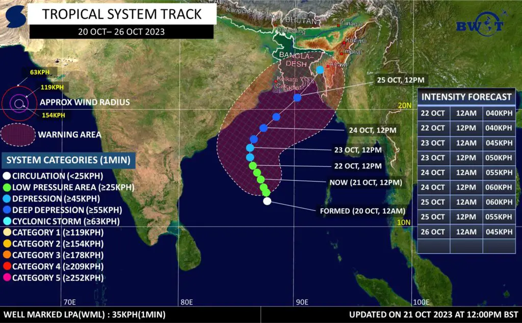
As of Saturday noon BST, “Invest 92B” has further moved north-westward and intensified into a Well Marked LPA. Currently, It is being located over Central and West Central Bay of Bengal as a Well Marked LPA.
Multi-spectral satellite animation is showing notable rotations with newly formed deep convection across the Low Level Circulation Center.
It is being located approximately 600km SE of Visakhapatnam, India.
★WINDS(1MIN AVG):-
Average Maximum Wind speed in radius of 50km from the low level center at 12pm Today is 35km/h. Gusting up to 45km/h.
★DYNAMIC ANALYSIS:-
Upper Level analysis indicates that the system is currently in a fairly favorable environment due to improved outflow, favorable SST (29-30°C), good lower level vorticity, decent moisture supply offsetting by absence of MJO, broad structure, descending branch of MJO and relevant atmospheric parameters.
•Due to the aforementioned conditions, It could intensify slowly but gradually into a Tropical Depression within next 24-48hrs & into a Deep Depression by early hours of 24th Oct. Overall conditions doesn’t support any significant Tropical Cyclone till now. Although, a low probability(<30%) of a minimal CS(<75kph) should be kept as the sea surface temperature and VWS is supportive throughout the potential track of the system.
.
•With the above atmospheric condition, the system is likely to peak near 55-65kph(~1min) with gusting up to 75-85kph.
★MOVEMENT:-
It was moved north-westward with the speed of 10kph during past 6hrs.
*From the present location, it could initially move NW towards West Central Bay of Bengal and intensify slowly but gradually.
Around 23rd Oct, it could recurve NE towards Bangladesh coast with gradual intensification up to a Deep Depression.
★LANDFALL:-
It could cross the Bangladesh coast between Barisial & Chittagong as a Depression or Deep Depression by 25th October.
★WARNING:–
Most parts of coastal Bangladesh, including parts of West Bengal coast, may experience 45-65kph winds with gusting up to 65-85kph by 25th of October 2023.
★ADVISORY:-
Fishermen & Small boats are requested not to venture into the deep sea along the track of the system during next 5 days. Everyone should cancel all tour plan into the deep sea for the given period which is close to the System Track.
Currently, whomever into the sea should stay close to the coast or avoid the risky area as stated here.
★RAINFALL:-
Due to the direct influence of the System, “Southern and Eastern Bangladesh” could have Heavy to Very Heavy rain along with Tropical Squalls between 24-27 Oct 2023. While Central Bangladesh and coastal West Bengal could have moderate to heavy rain.
*Rainfall activity could reduce significantly across Bangladesh from 27th Oct.
★Note: This information is subjective to change slightly. So, check new updates for better information!
Resources used in this analysis: Global Models, Himawari 9 Satellite, EWP, CCKW, 200hPa VP, 850hpa Vorticity, 500hPa Vorticity, 200hpa Winds, Sea Surface Temperature, OLR, WWB, EWB, ITCZ position, Synoptic Chart, Wind Shear, Subtropical Ridge.
Share as much as possible to inform everyone. Stay connected for next update!
Thanks, © Bangladesh Weather Observation Team (BWOT).
Advertisements